
Palisades Fire
MAP LINK:: CLICK FOR MAP WITH SEARCH BAR
DATE: February 13, 2025, 2025
TIME: 7:00AM
EVACUATION ORDERS for specific addresses and EVACUATION WARNINGS for several areas ARE NOW IN EFFECT from 7am today (2/13/2025) until 2pm tomorrow (2/14/2025), due to high mudslide and debris flow risk. These areas are recently burned and especially susceptible to heavy rain. PALISADES FIRE AREA: Getty Villa area, Highlands near the burned areas, Bienveneda area near Temescal Canyon Park, Reseda Blvd area/Marinette Road near Will Rogers State Park, Mandeville Canyon above Tanners Road. SUNSET FIRE AREA: East and South of Runyon Canyon. HURST FIRE AREA: Olive Lane in the Oakridge Mobile Home Park. ***Houses in the warning area with high risk will be visited by LAPD to issue specific evacuation orders.***
LAFD evacuation zone mapping is located HERE.
Find prediction details about the impacted areas in PHASE 2 maps HERE.
DATE: February 5, 2025, 2025
TIME: 7:00AM
Mayor Bass Launches the LA Disaster Relief Navigator at LACity.gov
LOS ANGELES – A new online tool to help Angelenos affected by the recent wildfires is now available at lacity.gov. Mayor Bass and the Mayor’s Fund for Los Angeles today launched the LA Disaster Relief Navigator, which gives Angelenos tailored resources and plans for recovery.
“Angelenos are continuing to navigate grief and shock. My commitment is to do everything we can to get people the help they need as conveniently as possible,” Mayor Bass said. “The Disaster Recovery Centers have already helped more than 5,000 families get help in person, and now the LA Disaster Relief Navigator will help Angelenos get help wherever they are. Thank you to Better Angels and Imagine LA for partnering with the Mayor's Fund and my office to make this resource a reality, and to the Annenberg Foundation and the R&S Kayne Foundation for their generous support and partnership.”
The LA Disaster Relief Navigator asks personalized questions to create individual Disaster Action Plans including government programs, insurance assistance, home damage remediation, temporary and permanent housing solutions, cash grants and valuable local community services.
"The navigator exists because of the hard work and expertise of Better Angels and Imagine LA, in partnership with the Mayor’s Office and the Mayor's Fund," said Conway Collis, President and CEO of the Mayor’s Fund for Los Angeles. "This important online tool helps Angelenos impacted by the wildfires, including people who are now facing job and income losses, access the many services available to them."
The LA Disaster Relief Navigator is the result of partnership between the developers, Better Angels and Imagine LA, and the Mayor’s Office and the Mayor’s Fund for Los Angeles. It was made possible through support from the Annenberg Foundation and the R&S Kayne Foundation Los Angeles.
The LA Disaster Relief Navigator is available at lacity.gov or accessible directly at wildfires.betterangels.la.
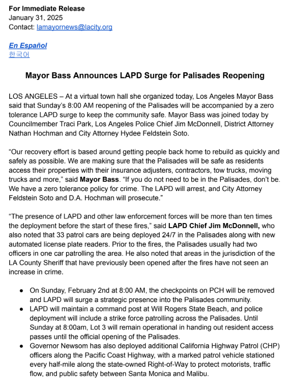
DATE: January 31, 2025
TIME: 7:45PM
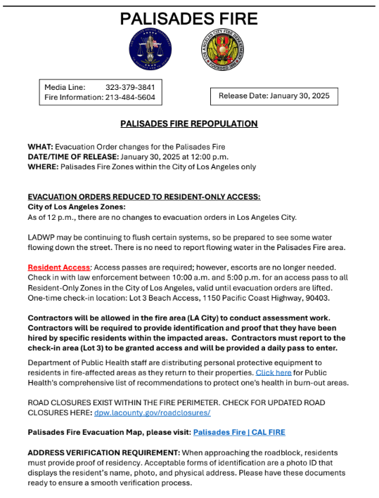
DATE: January 30, 2025
TIME: 12:00PM
DATE: January 29, 2025
TIME: 7:00PM
WEDNESDAY EVENING UPDATE: Impacted Palisades Residents Urged to Complete Right of Entry Form for Debris Removal Process
LOS ANGELES – Palisades Residents who lost their homes are urged to review and complete a Right of Entry Form, for free debris removal through the Army Corps of Engineers. The Army Corps of Engineers is encouraging residents to coordinate with their neighbors to help accelerate the process. Debris removal is an important part of the recovery process. The first step of debris removal, led by the federal EPA, is underway.
To participate, residents must complete the Right of Entry Form, which is now available to download or complete online and at Disaster Recovery Centers.
To participate in the free service, residents must complete a Right of Entry form by March 31, 2025. The US Army Corps of Engineers and their contractors cannot access a property to conduct the debris removal unless this form is completed.
Residents can call the Fire Debris Hotline with questions, or if they need help filling out the form at: 844-347-3332. In-person assistance also is available at the Disaster Recovery Centers open 9 AM to 8 PM.
The free debris removal program covers property assessment; asbestos removal; tree removal; ash and soil removal; burned debris removal; structural demolition; vehicle removal; erosional control; environmental monitoring; and potential foundation removal.
All residents in the Pacific Palisades can now access their properties. See more information on reentry guidance including knowing the risks and ways to keep safe on the City’s lacity.gov website.
Key information for returning residents includes the following:
Escorts are no longer required for entry to evacuation zones.
Checkpoints remain in place and proof-of-residence or entry pass will be required to enter these areas.
Resident and contractor access passes can be obtained 1150 Pacific Coast Highway - Lot 3 in the City of Santa Monica between 10 AM and 5 PM.
Key information for contractors:
Contractors will be allowed in the fire area.
Contractors will be required to provide identification and proof that they have been hired by specific residents within the impacted areas.
Contractors must report to the check-in area (Lot 3) each day to be granted access and will be provided a pass to enter.
Protect yourself from health and environmental hazards:
Wear a tight fitting N95 Mask or greater.
Wear household dishwashing gloves, long-sleeved shirts and long pants.
Wear safety goggles, not safety glasses.
Do not use leaf blowers or other equipment such as vacuum cleaners that may cause dust particles to be airborne.
Unified Command encourages residents who are re-entering the evacuation area to enter at their own risk and not sort through any fire debris – Know the risks. Stay safe.
EPA Emergency Response Deployed in Burn Areas
Environmental Protection Agency (EPA) Representatives have been assigned by the Federal Emergency Management Agency to survey, remove, and dispose of hazardous materials from properties burned by wildfires in Los Angeles County. EPA’s work removing hazardous materials is Phase 1 of the federal cleanup response. Further information can be found at epa.gov/california-wildfires.
Hazardous materials from burned properties require special handling and safe disposal by EPA’s cleanup crews. These materials will be sent to licensed disposal facilities (not municipal landfills). The EPA has been assessing and preparing to remove the first phase of debris - hazardous materials such as lithium batteries, asbestos, paints, cleaners and pesticides.
As part of the hazardous material removal work, U.S. EPA has also been tasked to safely remove batteries from electric and hybrid vehicles and home backup power supplies. According to the EPA, lithium-ion batteries should be considered extremely dangerous. For questions about this work or if you have an electric or hybrid vehicle and/or a battery energy storage system in the burn area, call the EPA hotline at 1-833-798-7372, dial 711, or email EPALAWildfiresInfo@epa.gov.
FEMA Resource Centers
In addition to the Disaster Recovery Centers, FEMA will be opening two new locations to provide support for people impacted by the recent fires – including the Hurst, Sunset, and Castaic fires – as they apply for FEMA assistance. FEMA has already approved over $52 million dollars in housing and other types of individual assistance with over 122,000 individuals already registered for FEMA assistance. The Deadline to Apply For Federal Assistance is March 10, 2025.
Sherman Oaks East Valley Adult Center
5056 Van Nuys Blvd Building B, Sherman Oaks, CA 91403
Tuesday - Friday, 9:30 AM - 5:00 PM
Ritchie Valens Recreation Center
10736 Laurel Canyon Blvd, Pacoima, CA 91331
Tuesday- Friday 9:00 AM - 3:00 PM & Saturday 1:00 PM - 6:00 PM
Services at these locations are limited to assistance with FEMA applications. FEMA can provide the following types of financial assistance:
Special Needs Assistance Grants – $770 one-time payment to afford immediate needs like food, water, hygiene, and transportation.
FEMA Individual Assistance For Housing – Homeowners can receive FEMA Individual Assistance grants for home repair, replacement, and for temporary housing up to $43,600.
FEMA Individual Assistance For Other Needs – Another $43,600 is available in the form of a grant from FEMA to cover medical expenses, damage to a vehicle, household items/property, funeral expenses, moving/storage, and childcare expenses, etc.
LA Department of Water and Power Palisades Restoration
If you have been allowed to return to your home and find your power out but your immediate neighbors’ electricity is on, please check your electrical panel. If your power is still out or the power remains out on your street or block, please contact 1-800-DIAL DWP to report the outage. It may be that LADWP crews are still inspecting the power lines that supply power to your street or block to ensure they are safe to restore. Performing the inspections and repairs enables crews to quickly and safely restore power to affected customers once Palisades Fire Unified Command lifts fire holds that are in place on certain power lines, for safety purposes. LADWP remains in close coordination with Unified Command and will continue working to restore power to customers, as clearance is received.
Do Not Drink Notice
Effective January 10, 2025, LADWP issued a Do Not Drink Notice in the zip code 90272 and the LADWP service area immediately south of the 90272 zip code and north of San Vicente Blvd. Check this interactive map to see if your area is affected and learn how it impacts your tap water.
LADWP is providing bottled drinking water to all impacted customers at these locations:
Veteran’s Barrington Park | 8:00 AM – 4:00 PM until further notice.
Palisades Branch Library | 8:00 AM – 4:00 PM until further notice.
Rustic Canyon Recreation Center | 8:00 AM – 4:00 PM until further notice.
LADWP Trailer Facility | 8:00 AM - 4:00 PM until further notice.
LAFD Fire Station 23 | 8:00 AM - 4:00 PM until further notice.
Monitor Air Quality
Continue to monitor air quality and wear a N95 mask when ash, smoke, dust is in the air. Explore the Air Quality Map from the South Coast Air Quality Management District (AQMD) for more details.
Find your local library and recreation center in Los Angeles to pick up free N95 masks.
Progress Toward Containment (as of Wednesday, 6:30 PM)
Palisades Fire is 97% contained – urgent work continues.
Eaton Fire, affecting communities outside the City of Los Angeles, is 99% contained.
DATE: January 29, 2025
TIME: 12:00PM
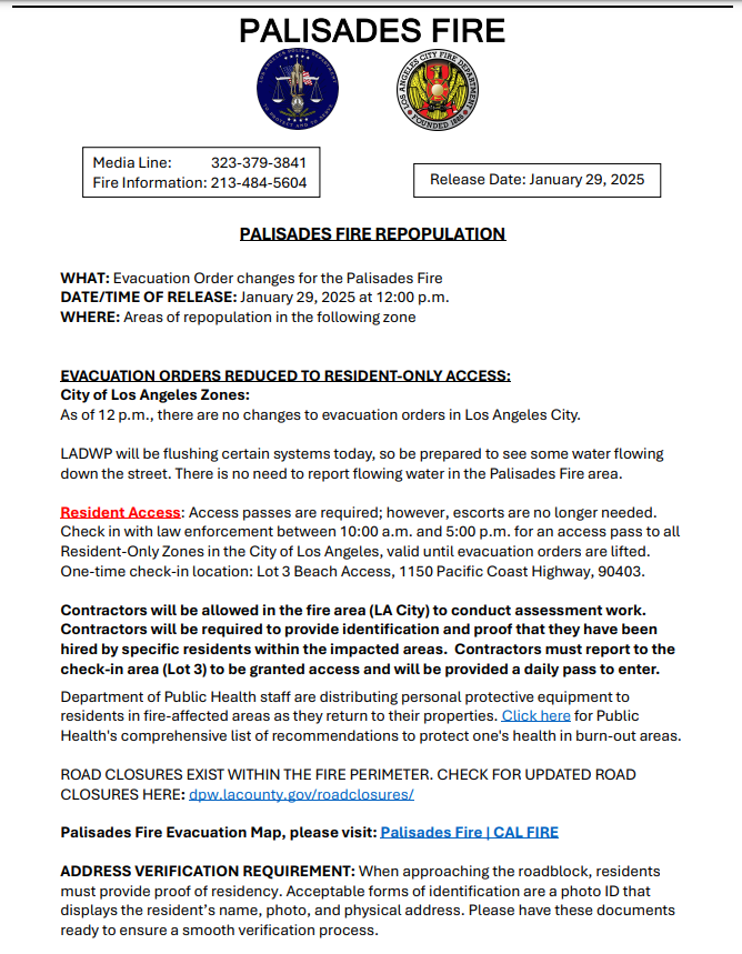
EVACUATION ORDERS REDUCED TO RESIDENT-ONLY ACCESS: City of Los Angeles Zones: As of 12 p.m., there are no changes to evacuation orders in Los Angeles City.
LADWP will be flushing certain systems today, so be prepared to see some water flowing down the street. There is no need to report flowing water in the Palisades Fire area.
Resident Access: Access passes are required; however, escorts are no longer needed. Check in with law enforcement between 10:00 a.m. and 5:00 p.m. for an access pass to all Resident-Only Zones in the City of Los Angeles, valid until evacuation orders are lifted. One-time check-in location: Lot 3 Beach Access, 1150 Pacific Coast Highway, 90403.
Contractors will be allowed in the fire area (LA City) to conduct assessment work. Contractors will be required to provide identification and proof that they have been hired by specific residents within the impacted areas. Contractors must report to the check-in area (Lot 3) to be granted access and will be provided a daily pass to enter.
See the official documentation reproduced below for further details:
DATE: January 28, 2025
TIME: 7:00AM
SIZE: 23, 488
CONTAINMENT: 95%
RESIDENT ACCESS:
- Curfew is now lifted.
- The Residents-Only access pass requires one-time check-in location: Lot 3 Beach Access, 1150 Pacific Coast Highway, Santa Monica, CA 90403. The pass is then valid for the remaining period until the restriction is lifted.
DATE: January 27, 2025
TIME: 12:30PM
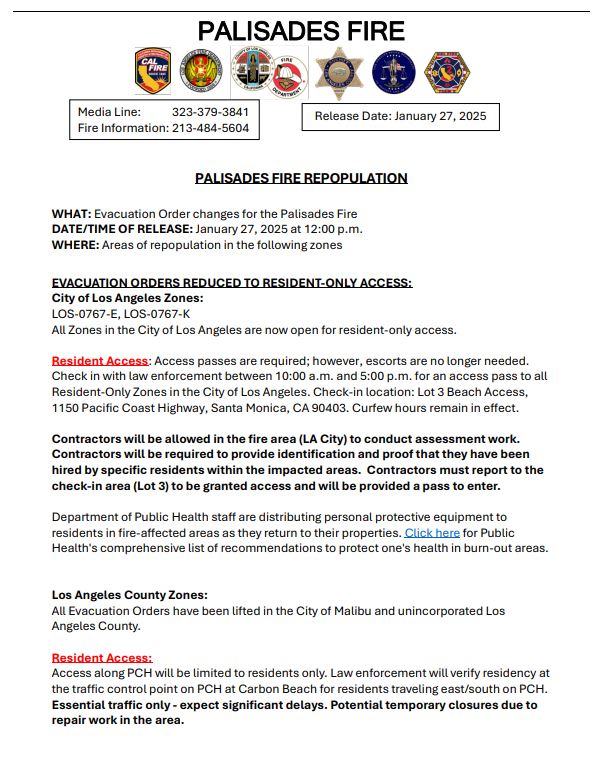
- REPOPULATION: EVACUATION ORDERS REDUCED TO RESIDENT-ONLY ACCESS:
- CITY OF LOS ANGELES ZONES: LOS-0767-E, LOS-0767-K
- All Zones in the City of Los Angeles are now open for resident-only access
- Resident Access: Access passes are required; however, escorts are no longer needed. Check in with law enforcement between 10:00 a.m. and 5:00 p.m. for an access pass to all Resident-Only Zones in the City of Los Angeles. Check-in location: Lot 3 Beach Access, 1150 Pacific Coast Highway, Santa Monica, CA 90403. Curfew hours remain in effect. Contractors will be allowed in the fire area (LA City) to conduct assessment work. Contractors will be required to provide identification and proof that they have been hired by specific residents within the impacted areas. Contractors must report to the check-in area (Lot 3) to be granted access and will be provided a pass to enter.
- Address Verification Requirement: When approaching the roadblock, residents must provide proof of residency. Acceptable forms of identification are a photo ID that displays the resident’s name, photo, and physical address. Please have these documents ready to ensure a smooth verification process.
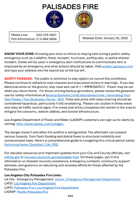
- Department of Public Health staff are distributing personal protective equipment to residents in fire-affected areas as they return to their properties. Click here for Public Health's comprehensive list of recommendations to protect one's health in burn-out areas
- LOS ANGELES COUNTY ZONES: All Evacuation Orders have been lifted in the City of Malibu and unincorporated Los Angeles County.
- Resident Access: Access along PCH will be limited to verified residents and essential contractors only. Residents need to go to Malibu City Hall between 10:00 a.m. and 5:00 p.m. to obtain a “Resident Only” pass and all Contractors need to go to the Lost Hills Sheriff Substation between 10:00 a.m. and 5:00 p.m. to obtain an “Essential Contractors” pass. Residents need to provide valid ID or proof of residency (utility bill or lease agreement showing an address in the affected area). Contractors/Essential personnel need to bring documentation showing that they are serving a resident in the affected areas. 10am-5pm. Essential traffic only - expect significant delays. Potential temporary closures due to repair work in the area.
- Address Verification Requirement: When approaching the roadblock, residents must provide proof of residency. Acceptable forms of identification are a photo ID that displays the resident’s name, photo, and physical address. Please have these documents ready to ensure a smooth verification process.
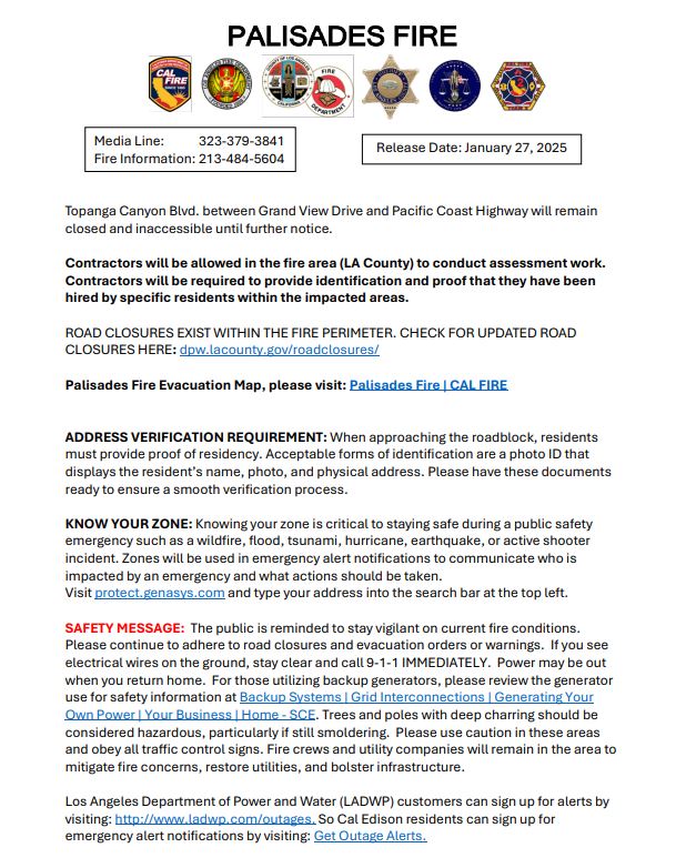
- Topanga Canyon Blvd. between Grand View Drive and Pacific Coast Highway will remain closed and inaccessible until further notice. Contractors will be allowed in the fire area (LA County) to conduct assessment work. Contractors will be required to provide identification and proof that they have been hired by specific residents within the impacted areas.
- ROAD CLOSURES EXIST WITHIN THE FIRE PERIMETER. CHECK FOR UPDATED ROAD CLOSURES HERE
- CITY OF LOS ANGELES ZONES: LOS-0767-E, LOS-0767-K
- SAFETY MESSAGE: The public is reminded to stay vigilant on current fire conditions. Please continue to adhere to road closures and evacuation orders or warnings. If you see electrical wires on the ground, stay clear and call 9-1-1 IMMEDIATELY. Power may be out when you return home. For those utilizing backup generators, please review the generator use for safety information at Backup Systems | Grid Interconnections | Generating Your Own Power | Your Business | Home - SCE. Trees and poles with deep charring should be considered hazardous, particularly if still smoldering. Please use caution in these areas and obey all traffic control signs. Fire crews and utility companies will remain in the area to mitigate fire concerns, restore utilities, and bolster infrastructure. Los Angeles Department of Power and Water (LADWP) customers can sign up for Outage Alerts. So Cal Edison residents can sign up for emergency alert notifications by visiting: Get Outage Alerts.
- The danger doesn’t end when the wildfire is extinguished. The aftermath can present various hazards, from flash flooding and debris flows to structural instability and compromised trees. Here’s a comprehensive guide to navigating this critical period safely:
- Returning Home Checklist | CAL FIRE. For valuable resources and important updates from your City and County officials, visit recovery.lacounty.gov/palisades-fire/. On this page, you’ll find information on disaster recovery assistance, emergency contacts, community support services, and guidance on rebuilding and recovery efforts for those affected by the Palisades Fire.
- Los Angeles City Palisades Fire Links:
- LA City - Emergency Management: Home | Emergency Management Department
- LAFD: Los Angeles Fire Department
- LADWP: Pacific Palisades Fire
- Los Angeles County Palisades Fire Links:
- LA County – Emergency Operations Center: Palisades Fire – LA County Recovers
- LA County Fire: Emergency Operations - Fire Department
- LA County Sheriff: Los Angeles County Sheriff's Department | A Tradition of Service
- So Cal Edison: Edison International Provides Update on Southern California Wildfires and SCE Power Outages
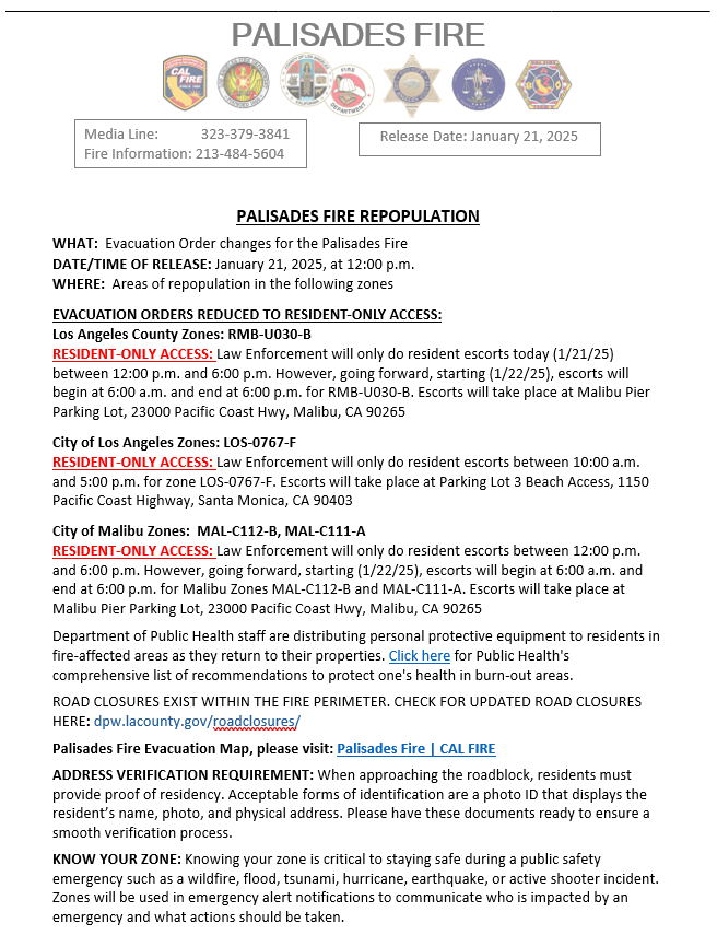
DATE: January 26, 2025
TIME: 1:00PM
- REPOPULATION: EVACUATION ORDERS REDUCED TO RESIDENT-ONLY ACCESS:
- City of Los Angeles Zones: LOS-0767-D (NORTH of W Sunset Blvd/Amalfi Dr, SOUTH of Rogers Fire Rd, EAST of Temescal Canyon Rd, WEST of W Sunset Blvd/Amalfi Dr)
- Resident Access: Law Enforcement will only conduct resident escorts between 10:00 a.m. and 5:00 p.m. for Zone LOS-0767-D and previously repopulated areas. Please arrive no later than 4:30 p.m. Escorts will occur at Parking Lot 3 Beach Access, 1150 Pacific Coast Highway, Santa Monica, CA 90403. Curfew hours remain in effect.
- On the days following repopulation, residents in the previously opened zones - LOS-0767-J, LOS-0767-G, LOS-0767-F, LOS-0767-A, LOS-0767-H, LOS-0767-I, LOS-0767-L, LOS-767-D (today) —will be permitted to enter the checkpoint between 10:00 a.m. and 5:00 p.m.
- Los Angeles County Zones: All fire areas in the City of Malibu and unincorporated Los Angeles County are open to
Residents Only- Resident Access: Residents in the Residents Only Zones - TOP-U007-A, RRC-U027-C, MTN-U028-A,
SDP-U029-A, RMB-U030-A, RMB-U030-B, RMB-U030-F, RMB-U030-G, MAL-C111-A, MAL-C112-B, TOP-U009-A, TOP-U008-B, SSM-U010-A, SSM-U010-B, MAL-C111-B - will be permitted to enter at the traffic control points between 6:00 a.m. and 6:00 p.m. Curfew hours remain in effect.
- Resident Access: Residents in the Residents Only Zones - TOP-U007-A, RRC-U027-C, MTN-U028-A,
- Department of Public Health staff are distributing personal protective equipment to residents in fire-affected areas as they return to their properties. Click here for Public Health's comprehensive list of recommendations to protect one's health in burn-out areas.
- Topanga Canyon Blvd. between Grand View Drive and Pacific Coast Highway will remain closed and inaccessible until further notice.
- ROAD CLOSURES EXIST WITHIN THE FIRE PERIMETER. CHECK FOR UPDATED ROAD CLOSURES HERE: dpw.lacounty.gov/roadclosures/
- ADDRESS VERIFICATION REQUIREMENT: When approaching the roadblock, residents must provide proof of residency. Acceptable forms of identification are a photo ID that displays the resident’s name, photo, and physical address. Please have these documents ready to ensure a smooth verification process.
- KNOW YOUR ZONE: Knowing your zone is critical to staying safe during a public safety emergency such as a wildfire, flood, tsunami, hurricane, earthquake, or active shooter incident. Zones will be used in emergency alert notifications to communicate
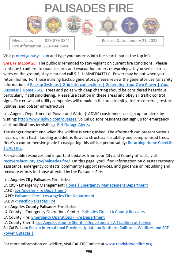
who is impacted by an emergency and what actions should be taken. Visit protect.genasys.com and type your address into the search bar at the top left. - SAFETY MESSAGE: The public is reminded to stay vigilant on current fire conditions. Please continue to adhere to road closures and evacuation orders or warnings. If you see electrical wires on the ground, stay clear and call 9-1-1 IMMEDIATELY. Power may be out when you return home. For those utilizing backup generators, please review the generator use for safety information at Backup Systems | Grid Interconnections | Generating Your Own Power | Your Business | Home - SCE. Trees and poles with deep charring should be considered hazardous, particularly if still smoldering. Please use caution in these areas and obey all traffic control signs. Fire crews and utility companies will remain in the area to mitigate fire concerns, restore utilities, and bolster infrastructure.
- City of Los Angeles Zones: LOS-0767-D (NORTH of W Sunset Blvd/Amalfi Dr, SOUTH of Rogers Fire Rd, EAST of Temescal Canyon Rd, WEST of W Sunset Blvd/Amalfi Dr)
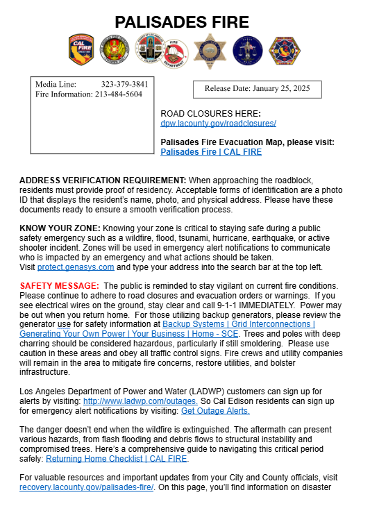
DATE: January 25, 2025
TIME: 12:00PM
- REPOPULATION: EVACUATION ORDERS REDUCED TO RESIDENT-ONLY ACCESS:
- City of Los Angeles Zones: LOS-0767-L (NORTH of Alma Real Dr, Pacific Coast Hwy, SOUTH of W Sunset Blvd, EAST of Temescal Canyon Rd, WEST of Ocampo Dr, Chautauqua Blvd, Toyopa Dr)
- Resident Access: Law Enforcement will only conduct resident escorts between 10:00 a.m. and 5:00 p.m. for Zone LOS-0767-L and previously repopulated areas. Please arrive no later than 4:30 p.m. Escorts will occur at Parking Lot 3 Beach Access, 1150 Pacific Coast Highway, Santa Monica, CA 90403. Curfew hours remain in effect.
- City of Los Angeles Zones: LOS-0767-L (NORTH of Alma Real Dr, Pacific Coast Hwy, SOUTH of W Sunset Blvd, EAST of Temescal Canyon Rd, WEST of Ocampo Dr, Chautauqua Blvd, Toyopa Dr)
- On the days following repopulation, residents in the previously opened zones - LOS-0767-J, LOS-0767-G, LOS-0767-F, LOS-0767-A, LOS-0767-H, LOS-0767-I, LOS-0767-L (today)—will be permitted to enter the checkpoint between 10:00 a.m. and 5:00 p.m.
- Department of Public Health staff are distributing personal protective equipment to residents in fire-affected areas as they return to their properties.
- Topanga Canyon Blvd. between Grand View Drive and Pacific Coast Highway will remain closed and inaccessible until further notice.
- ROAD CLOSURES EXIST WITHIN THE FIRE PERIMETER. CHECK FOR UPDATED ROAD CLOSURES HERE: dpw.lacounty.gov/roadclosures/
- ADDRESS VERIFICATION REQUIREMENT: When approaching the roadblock, residents must provide proof of residency. Acceptable forms of identification are a photo ID that displays the resident’s name, photo, and physical address. Please have these documents ready to ensure a smooth verification process.
- KNOW YOUR ZONE: Knowing your zone is critical to staying safe during a public safety emergency such as a wildfire, flood, tsunami, hurricane, earthquake, or active shooter incident. Zones will be used in emergency alert notifications to communicate
who is impacted by an emergency and what actions should be taken. Visit protect.genasys.com and type your address into the search bar at the top left. - SAFETY MESSAGE: The public is reminded to stay vigilant on current fire conditions. Please continue to adhere to road closures and evacuation orders or warnings. If you see electrical wires on the ground, stay clear and call 9-1-1 IMMEDIATELY. Power may be out when you return home. For those utilizing backup generators, please review the generator use for safety information at Backup Systems | Grid Interconnections | Generating Your Own Power | Your Business | Home - SCE. Trees and poles with deep charring should be considered hazardous, particularly if still smoldering. Please use caution in these areas and obey all traffic control signs. Fire crews and utility companies will remain in the area to mitigate fire concerns, restore utilities, and bolster infrastructure.
DATE: January 24, 2025
TIME: 12:00PM
- REPOPULATION: EVACUATION ORDERS REDUCED TO RESIDENT-ONLY ACCESS:
- City of Los Angeles Zones: LOS-0767-I (NORTH of Chautauqua Blvd, SOUTH of Sullivan Fire Rd, EAST of Temescal Fire Rd, WEST of Old Ranch Rd/Mandeville Canyon Rd/Casale Rd)
- Resident Access: Law Enforcement will only conduct resident escorts between 10:00 a.m. and 5:00 p.m. for Zone LOS-0767-I and previously repopulated areas. Please arrive no later than 4:30 p.m. Escorts will occur at Parking Lot 3 Beach Access, 1150 Pacific Coast Highway, Santa Monica, CA 90403. Curfew hours remain in effect.
- City of Los Angeles Zones: LOS-0767-I (NORTH of Chautauqua Blvd, SOUTH of Sullivan Fire Rd, EAST of Temescal Fire Rd, WEST of Old Ranch Rd/Mandeville Canyon Rd/Casale Rd)
- On the days following repopulation, residents in the previously opened zones - LOS-0767-J, LOS-0767-G, LOS-0767-F, LOS-0767-A, LOS-0767-H, LOS-0767-I (today) - will be permitted to enter at the checkpoint between 10:00 a.m. and 5:00 p.m.
- Department of Public Health staff are distributing personal protective equipment to residents in fire-affected areas as they return to their properties.
- Topanga Canyon Blvd. between Grand View Drive and Pacific Coast Highway will remain closed and inaccessible until further notice.
- ADDRESS VERIFICATION REQUIREMENT: When approaching the roadblock, residents must provide proof of residency. Acceptable forms of identification are a photo ID that displays the resident’s name, photo, and physical address. Please have these
documents ready to ensure a smooth verification process. - KNOW YOUR ZONE: Knowing your zone is critical to staying safe during a public safety emergency such as a wildfire, flood, tsunami, hurricane, earthquake, or active shooter incident. Zones will be used in emergency alert notifications to communicate
who is impacted by an emergency and what actions should be taken. - SAFETY MESSAGE: The public is reminded to stay vigilant on current fire conditions. Please continue to adhere to road closures and evacuation orders or warnings. If you see electrical wires on the ground, stay clear and call 9-1-1 IMMEDIATELY. Power may be out when you return home. For those utilizing backup generators, please review the generator use for safety information at Backup Systems | Grid Interconnections | Generating Your Own Power | Your Business | Home - SCE. Trees and poles with deep charring should be considered hazardous, particularly if still smoldering. Please use caution in these areas and obey all traffic control signs. Fire crews and utility companies will remain in the area to mitigate fire concerns, restore utilities, and bolster infrastructure.
DATE: January 23, 2025
TIME: 12:00PM
- REPOPULATION: EVACUATION ORDERS REDUCED TO RESIDENT-ONLY ACCESS:
- City of Los Angeles Zones: LOS-0767-H (NORTH of Oman Air Los Angeles Ofc, SOUTH of Farmer Fire Rd, EAST of Eagle Springs Fire Rd WEST of Mandeville Canyon Rd, Sherry Ln)
Resident Access: Law Enforcement will only do resident escorts between 10:00 a.m. and 5:00 p.m. for Zone LOS-0767-H and previously repopulated areas. Please arrive no later than 4:30 p.m. Escorts will occur at Parking Lot 3 Beach Access, 1150 Pacific Coast Highway, Santa Monica, CA 90403.
On the days following repopulation, residents in the previously opened zones - LOS-0767-J, LOS-0767-G, LOS-0767-F, LOS-0767-A, LOS-0767-H (today) - will be permitted to enter at the checkpoint between 10:00 a.m. and 5:00 p.m.
Department of Public Health staff are distributing personal protective equipment to residents in fire-affected areas as they return to their properties. Click here for Public Health's comprehensive list of recommendations to protect one's health in burn-out areas.
- Los Angeles County Zones: TOP-U009-A, TOP-U008-B, SSM-U010-A, SSM-U010-B, MAL-C111-B
Resident Access: Newly repopulated residents need to check in at the staging area located at the Malibu Pier (23000 Pacific Coast Highway, Malibu). At the staging area, residents will receive further instructions from Los Angeles County Fire personnel, be escorted by Los Angeles County Sheriff Deputies to the checkpoint and be allowed access to the repopulated areas.
Escorts for newly repopulated zones will be conducted from 12:00 p.m. to 6:00 p.m. On the days following repopulation, residents in the previously opened zones - TOP-U007-A, RRC-U027-C, MTN-U028-A, SDP-U029-A, RMB-U030-A, RMB-U030-B, RMB-U030-F, RMB-U030-G, MAL-C111-A, MAL-C112-B - will be permitted to enter at the checkpoint between 6:00 a.m. and 5:30 p.m. Curfew hours remain in effect.
Support staff are distributing supplies to residents in fire-affected areas as they return to their properties.
- City of Los Angeles Zones: LOS-0767-H (NORTH of Oman Air Los Angeles Ofc, SOUTH of Farmer Fire Rd, EAST of Eagle Springs Fire Rd WEST of Mandeville Canyon Rd, Sherry Ln)
- ROAD CLOSURES EXIST WITHIN THE FIRE PERIMETER. CHECK FOR UPDATED ROAD CLOSURES HERE: dpw.lacounty.gov/roadclosures/
ADDRESS VERIFICATION REQUIREMENT: When approaching the roadblock, residents must provide proof of residency. Acceptable forms of identification are a photo ID that displays the resident’s name, photo, and physical address. Please have these documents ready to ensure a smooth verification process.
KNOW YOUR ZONE: Knowing your zone is critical to staying safe during a public safety emergency such as a wildfire, flood, tsunami, hurricane, earthquake, or active shooter incident. Zones will be used in emergency alert notifications to communicate who is impacted by an emergency and what actions should be taken. See map link at the top of the page.
SAFETY MESSAGE: The public is reminded to stay vigilant on current fire conditions. Please continue to adhere to road closures and evacuation orders or warnings. If you see electrical wires on the ground, stay clear and call 9-1-1 IMMEDIATELY. Power may be out when you return home. For those utilizing backup generators, please review the generator use for safety information at Backup Systems | Grid Interconnections | Generating Your Own Power | Your Business | Home - SCE. Trees and poles with deep charring should be considered hazardous, particularly if still smoldering. Please use caution in these areas and obey all traffic control signs. Fire crews and utility companies will remain in the area to mitigate fire concerns, restore utilities, and bolster infrastructure.
Los Angeles Department of Power and Water (LADWP) customers can sign up for alerts by visiting: http://www.ladwp.com/outages. So Cal Edisons residents can sign up for emergency alert notifications by visiting: Get Outage Alerts.
The danger doesn’t end when the wildfire is extinguished. The aftermath can present various hazards, from flash flooding and debris flows to structural instability and compromised trees. Here’s a comprehensive guide to navigating this critical period safely: Returning Home Checklist | CAL FIRE.
- For valuable resources and important updates from your City and County officials, visit recovery.lacounty.gov/palisades-fire/. On this page, you’ll find information on disaster recovery assistance, emergency contacts, community support services, and guidance on rebuilding and recovery efforts for those affected by the Palisades Fire.
- Los Angeles City Palisades Fire Links:
- LA City - Emergency Management: Home | Emergency Management Department
- LAFD: Los Angeles Fire Department
- LAPD: Palisades Fire | Los Angeles Fire Department
- LADWP: Pacific Palisades Fire
- Los Angeles County Palisades Fire Links:
- LA County – Emergency Operations Center: Palisades Fire – LA County Recovers
- LA County Fire: Emergency Operations - Fire Department
- LA County Sheriff: Los Angeles County Sheriff's Department | A Tradition of Service
- So Cal Edison: Edison International Provides Update on Southern California Wildfires and SCE Power Outages |
DATE: January 22, 2025
TIME: 12:00PM
- REPOPULATION: EVACUATION ORDERS REDUCED TO RESIDENT-ONLY ACCESS:
- City of Los Angeles Zones: LOS-0767-A (NORTH of S Topanga Canyon Blvd, Trailer Canyon Fire Rd, E Topanga Fire Rd SOUTH of Mulholland Dr EAST of Rochemont Dr WEST of Temescal Fire Rd)
Resident Access: Law Enforcement will only do resident escorts between 10:00 a.m. and 5:00 p.m. for Zone LOS-0767-A and previously repopulated areas. Please arrive no later than 4:30 p.m. Escorts will occur at Parking Lot 3 Beach Access, 1150 Pacific Coast Highway, Santa Monica, CA 90403.
- Department of Public Health staff are distributing personal protective equipment to residents in fire-affected areas as they return to their properties. Click here for Public Health's comprehensive list of recommendations to protect one's health in burn-out areas.
- Los Angeles County Zones: RMB-U030-A, RMB-U030-F, RMB-U030-G, SDP-U029-A, RRC-U027-C MTN-U028-A
Resident Access: Newly repopulated residents need to check in at the staging area located at the Malibu Pier (23000 Pacific Coast Highway, Malibu). At the staging area, residents will receive further instructions from Los Angeles County Fire personnel, be escorted by Los Angeles County Sheriff Deputies to the checkpoint and be allowed access to the repopulated areas.
Escorts for newly repopulated zones will be conducted from 12:00 p.m. to 6:00 p.m. On the days following repopulation, residents in the previously opened zones will be permitted to enter at the checkpoint between 6:00 a.m. and 6:30 p.m. Curfew hours remain in effect.
Support staff are distributing supplies to residents in fire-affected areas as they return to their properties.
- City of Los Angeles Zones: LOS-0767-A (NORTH of S Topanga Canyon Blvd, Trailer Canyon Fire Rd, E Topanga Fire Rd SOUTH of Mulholland Dr EAST of Rochemont Dr WEST of Temescal Fire Rd)
- ROAD CLOSURES EXIST WITHIN THE FIRE PERIMETER. CHECK FOR UPDATED ROAD CLOSURES HERE: dpw.lacounty.gov/roadclosures/
ADDRESS VERIFICATION REQUIREMENT: When approaching the roadblock, residents must provide proof of residency. Acceptable forms of identification are a photo ID that displays the resident’s name, photo, and physical address. Please have these documents ready to ensure a smooth verification process.
KNOW YOUR ZONE: Knowing your zone is critical to staying safe during a public safety emergency such as a wildfire, flood, tsunami, hurricane, earthquake, or active shooter incident. Zones will be used in emergency alert notifications to communicate who is impacted by an emergency and what actions should be taken. See map link at the top of the page.
SAFETY MESSAGE: The public is reminded to stay vigilant on current fire conditions. Please continue to adhere to road closures and evacuation orders or warnings. If you see electrical wires on the ground, stay clear and call 9-1-1 IMMEDIATELY. Power may be out when you return home. For those utilizing backup generators, please review the generator use for safety information at Backup Systems | Grid Interconnections | Generating Your Own Power | Your Business | Home - SCE. Trees and poles with deep charring should be considered hazardous, particularly if still smoldering. Please use caution in these areas and obey all traffic control signs. Fire crews and utility companies will remain in the area to mitigate fire concerns, restore utilities, and bolster infrastructure.
Los Angeles Department of Power and Water (LADWP) customers can sign up for alerts by visiting: http://www.ladwp.com/outages. So Cal Edisons residents can sign up for emergency alert notifications by visiting: Get Outage Alerts.
The danger doesn’t end when the wildfire is extinguished. The aftermath can present various hazards, from flash flooding and debris flows to structural instability and compromised trees. Here’s a comprehensive guide to navigating this critical period safely: Returning Home Checklist | CAL FIRE.
- For valuable resources and important updates from your City and County officials, visit recovery.lacounty.gov/palisades-fire/. On this page, you’ll find information on disaster recovery assistance, emergency contacts, community support services, and guidance on rebuilding and recovery efforts for those affected by the Palisades Fire.
- Los Angeles City Palisades Fire Links:
- LA City - Emergency Management: Home | Emergency Management Department
- LAFD: Los Angeles Fire Department
- LAPD: Palisades Fire | Los Angeles Fire Department
- LADWP: Pacific Palisades Fire
- Los Angeles County Palisades Fire Links:
- LA County – Emergency Operations Center: Palisades Fire – LA County Recovers
- LA County Fire: Emergency Operations - Fire Department
- LA County Sheriff: Los Angeles County Sheriff's Department | A Tradition of Service
- So Cal Edison: Edison International Provides Update on Southern California Wildfires and SCE Power Outages |
DATE: January 21, 2025
TIME: 7PM
- SIZE: 23,448 acres with 65% containment
- CURFEW: For the safety of residents, all Evacuation Order and Warning Areas remain under a 6AM to 6PM curfew.
- STRUCTURES DESTROYED: 6,528
- STRUCTURES DAMAGED: 882
DATE: January 21, 2025
TIME: 12PM
- REPOPULATION:
- EVACUATION ORDERS REDUCED TO RESIDENT-ONLY ACCESS:
- Los Angeles County Zones: RMB-U030-B
- NORTH of Carbon Beach Ter, SOUTH of Piuma Rd, EAST of Carbon Canyon Rd, WEST of Carbon Canyon Rd
- City of Los Angeles Zones: LOS-0767-F
- NORTH of Pacific Coast Highway, SOUTH of Santa Ynez Rd, EAST of S Surfview Dr, WEST of Palisades Dr
- City of Malibu Zones: MAL-C112-B, MAL-C111-A
- NORTH of Pacific Coast Highway, SOUTH of Carbon Beach Ter, EAST of Carbon Beach Ter, WEST of Carbon Beach Ter
- NORTH of Pacific Coast Highway, SOUTH of Rambla Pacifico St, EAST of Carbon Beach Ter, WEST of Las Flores Mesa Dr
- Los Angeles County Zones: RMB-U030-B
- Department of Public Health staff are distributing personal protective equipment to residents in fire-affected areas as they return to their properties. Click here for Public Health's comprehensive list of recommendations to protect one's health in burn-out areas.
- ADDRESS VERIFICATION REQUIREMENT: When approaching the roadblock, residents must provide proof of residency. Acceptable forms of identification are a photo ID that displays the resident’s name, photo, and physical address. Please have these documents ready to ensure a smooth verification process.
- KNOW YOUR ZONE: Knowing your zone is critical to staying safe during a public safety emergency such as a wildfire, flood, tsunami, hurricane, earthquake, or active shooter. The map to find your zone is linked above.
- See images below for full reproduction of official documentation:
- EVACUATION ORDERS REDUCED TO RESIDENT-ONLY ACCESS:
DATE: January 21, 2025
TIME: 7AM
- SIZE: 23,713 acres with 63% containment
- CURFEW: For the safety of residents, all Evacuation Order and Warning Areas remain under a 6AM to 6PM curfew.
- STRUCTURES DESTROYED: 6,380
- STRUCTURES DAMAGED: 857
DATE: January 20, 2025
TIME: 7PM
- SIZE: 23,713 acres with 61% containment
- CURFEW: For the safety of residents, all Evacuation Order and Warning Areas remain under a 6AM to 6PM curfew.
- STRUCTURES DESTROYED: 6,207
- STRUCTURES DAMAGED: 821
- REPOPULATION: The evacuation zones have changed today. Please see those updates below.
- RECOVERY: For assistance, tips and resources during your recovery process: https://emergency.lacity.gov/recovery
- DISASTER RESOURCES CENTER:
- Location: UCLA Research Park West (formerly known as the Westside Pavillion) 10850 Pico Blvd
- Hours: 9AM - 8PM, 7 days per week
- In person help for:
- Lost vital records (birth certificates, death certificates, driver's licenses, social security documentation)
- Disaster relief loans for those who lost their homes or businesses
- Referrals for mental health counseling and other services
DATE: January 20, 2025
TIME: 7AM
- REPOPULATION:
- EVACUATION ORDERS REDUCED TO RESIDENT-ONLY ACCESS:
- TOP-U007-A
- NORTH of S Topanga Canyon Blvd, SOUTH of Encina Rd, EAST of S Topanga Canyon Blvd, WEST of Amy Way/Colina Dr
- TOP-U007-A
- ADDRESS VERIFICATION REQUIREMENT: When approaching the roadblock, residents must provide proof of residency. Acceptable forms of identification are a photo ID that displays the resident’s name, photo, and physical address. Please have these documents ready to ensure a smooth verification process.
- KNOW YOUR ZONE: Knowing your zone is critical to staying safe during a public safety emergency such as a wildfire, flood, tsunami, hurricane, earthquake, or active shooter. The map to find your zone is linked above.
- EVACUATION ORDERS REDUCED TO RESIDENT-ONLY ACCESS:
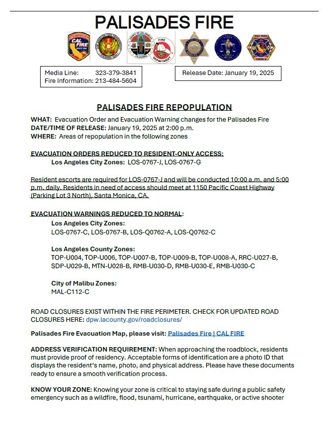
DATE: January 19, 2025
TIME: 7PM
SIZE: 23, 713 acres with 56% containment
DATE: January 19, 2025
TIME: 1:30PM
- REPOPULATION:
- EVACUATION ORDERS REDUCED TO RESIDENT-ONLY ACCESS:
- LOS-0767-J
- NORTH of Santa Ynez Rd, SOUTH of Temescal Fire Rd, EAST of E Topanga Fire Rd, Colina Dr WEST of Temescal Fire Rd
- LOS-0767-G
- NORTH of Observation Dr, SOUTH of Topanga Canyon Blvd, EAST of Montau Dr, WEST of Topanga Canyon Rd
- LOS-0767-J
- RESIDENT ESCORTS: Required for LOS-0767-J and will be conducted 10:00 a.m. and 5:00 p.m. daily. Residents in need of access should meet at 1150 Pacific Coast Highway (Parking Lot 3 North), Santa Monica, CA.
- ADDRESS VERIFICATION REQUIREMENT: When approaching the roadblock, residents must provide proof of residency. Acceptable forms of identification are a photo ID that displays the resident’s name, photo, and physical address. Please have these documents ready to ensure a smooth verification process.
- EVACUATION WARNINGS REDUCED TO NORMAL:
- LOS-0767-C, LOS-0767-B, LOS-Q0762-A, LOS-Q0762-C
- The street descriptions for this entire area are:
- NORTH of Pacific Coast Highway
- WEST of S Cliffwood Ave / Canyonback Rd / Mulholland Dr / Escalon Dr / Encino Hills Dr
- SOUTH of Reseda Blvd / Lochgreen Dr / Vanalden Ave
- EAST of Casale Rd / Mandeville Canyon Rd / Mulholland Dr / Vanalden Ave
- The street descriptions for this entire area are:
- LOS-0767-C, LOS-0767-B, LOS-Q0762-A, LOS-Q0762-C
- EVACUATION ORDERS REDUCED TO RESIDENT-ONLY ACCESS:
- KNOW YOUR ZONE: Knowing your zone is critical to staying safe during a public safety emergency such as a wildfire, flood, tsunami, hurricane, earthquake, or active shooter. The map to find your zone is linked above.
TIME: 7:00AM
- SIZE: 23, 713 acres with 52% containment
- CURFEW: For the safety of residents, all Evacuation Order and Warning Areas remain under a 6AM to 6PM curfew.
- STRUCTURES DESTROYED: 4,996
- STRUCTURES DAMAGED: 707
- REPOPULATION: The evacuation zones have changed as of 2PM January 18, 2025. Please see those updates below
- RECOVERY: For assistance, tips and resources during your recovery process: https://emergency.lacity.gov/recovery
- DISASTER RESOURCES CENTER:
- Location: UCLA Research Park (formerly known as the Westside Pavillion) 10850 Pico Blvd
- Hours: 9AM - 8PM, 7 days per week
- In person help for:
- Lost vital records (birth certificates, death certificates, driver's licenses, social security documentation)
- Disaster relief loans for those who lost their homes or businesses
- Referrals for mental health counseling and other services
DATE: January 18, 2025
TIME: 2:00PM
- PARTIAL REPOPULATION Repopulation continues with some zones being reduced from warning/residents only down to normal. Some zones are being reduced from warning down to normal. To find your zone, click on the map link above and type in your address.
- RESIDENTS-ONLY ACCESS REDUCED TO WARNING:
- LOS-Q0762-A, LOS-Q0767-B, LOS-Q0767-C
- EVACUATION ORDERS AND WARNINGS REDUCED TO NORMAL:
- LOS-Q0406-A, LOS-Q0407, LOS-Q0762-B, LOS-Q0765, LOS-Q0778-A, LOS-Q0779, LOS-Q0780, LOS-Q0781-A, LOS-Q0782-A, LOS-Q0782-B, LOS-Q0782-C, LOS-Q0798, LOS-Q1115-A, LOS-Q1115-B, LOS-Q1118
- RESIDENTS-ONLY ACCESS REDUCED TO WARNING:
- RECOVERY: For assistance, tips and resources during your recovery process: https://emergency.lacity.gov/recovery
- Disaster Resources Center:
- Location: UCLA Research Park (formerly known as the Westside Pavillion) 10850 Pico Blvd
- Hours: 9AM - 8PM, 7 days per week
- In person help for:
- Lost vital records (birth certificates, death certificates, driver's licenses, social security documentation)
- Disaster relief loans for those who lost their homes or businesses
Referrals for mental health counseling and other services
DATE: January 17, 2025
TIME: 3:00PM
- PARTIAL REPOPULATION Repopulation continues with some zones being opened to residents only, while some zones are reduced from warning down to normal. There is a long list of zones provided below and a map is linked above to make it easier to find your zone. Proof of residency requirements and all safety messages from the 7AM update below still apply. Please be sure to read them before making entry.
- Mandatory Evacuation Zones are being opened to Resident-Only Access
- LOS-Q0762-A
- NORTH of Mulholland Dr
- SOUTH of Alonzo Ave
- EAST of Mulholland Dr
- WEST of Mulholland Dr, Escalon Dr, Encino Hills Dr
- LOS-Q0767-B
- NORTH of Arbutus Way, Mandeville Canyon Rd, N Kenter Ave
- SOUTH of Mulholland Dr, Canyonback Rd
- EAST of Mandeville Canyon Rd
- WEST of Canyonback Rd
- LOS-Q0767-C
- NORTH of Woodacres Rd, Pacific Coast Hwy
- SOUTH of Mandeville Canyon Rd, Pesquera Dr, Elkins Rd
- EAST of Casale Rd
- WEST of S Cliffwood Ave
- LOS-Q0782-C
- NORTH of Carrara Pl, Kenfield Ave, N Kenter Ave
- SOUTH of N Kenter Ave
- EAST of N Kenter Ave
- WEST of Mount Saint Marys Fire Rd
- LOS-Q0762-A
- Resident-Only Access Zones Reduced to Warning Zones:
- LOS-Q1118
- NORTH of Mission Canyon Road
- SOUTH of Meadow Ridge Road, Hayvenhurst Avenue
- EAST of Calneva Drive
- WEST of Sepulveda Boulevard, Valley Meadow Place, Royal Oak Road
- LOS-Q0765
- NORTH of Standish, Mulholland Drive
- SOUTH of Adlon Road EAST of Escalon Drive
- WEST of Hayvenhurst Avenue)
- LOS-Q0778-A \
- NORTH of Canyonback Rd
- SOUTH of Canyonback Rd, Mission Dump Rd
- EAST of Canyonback Rd
- WEST of Canyonback Rd)
- LOS-Q0798
- NORTH of San Diego Freeway
- SOUTH of Mulholland Drive
- EAST of Canyonback Road, Mulholland Drive
- WEST of San Diego Freeway, Mulholland Drive
- LOS-Q-0780
- NORTH of North Kenter Avenue, Greenock Lane
- SOUTH of North Kenter Avenue, Sky Lane, Travis Street, North Tigertail Road
- EAST of Access Road for Power Lines
- WEST of Greenock Lane, Travis Street
- LOS-Q0781-A
- NORTH of Promontory Rd, Mount Saint Marys Fire Rd
- SOUTH of Canyonback Rd, Mission Dump Rd
- EAST of Canyonback Rd
- WEST of I-405 N)
- LOS-Q0782-A
- NORTH of Getty Center Dr, Mount Saint Marys Fire Rd, N Bundy Dr
- SOUTH of Promontory Rd, Mount Saint Marys Fire Rd
- EAST of Mount Saint Marys Fire Rd
- WEST of I-405 N)
- LOS-Q0782-B
- NORTH of Canyonback Rd, Mission Dump Rd
- SOUTH of Park Lane Cir, Mulholland Dr, Sloan Dr
- EAST of Canyonback Rd
- WEST of N Sepulveda Blvd)
- LOS-Q1118
- Zones Reduced from Warning Zones to Normal (No evacuation):
- LOS-Q0751
- NORTH of Ulmus Drive
- SOUTH of Mulholland Drive
- EAST of Mulholland Drive
- WEST of Mulholland Drive
- LOS-Q0764
- NORTH of Louise Avenue, Adlon Road
- SOUTH of Balboa Boulevard
- EAST of Louise Avenue
- WEST of Hayvenhurst Avenue
- LOS-Q0772
- NORTH of Mulholland Drive, Woodcliff Road
- SOUTH of Saugus Avenue
- EAST of San Diego Freeway
- WEST of Woodcliff Road)
- LOS-Q0783
- NORTH of San Diego Freeway, Weybridge Lane
- SOUTH of Duomo via Street, San Diego Freeway
- EAST of San Diego Freeway
- WEST of Duomo via Street
- LOS-Q0800
- NORTH of West Sunset Boulevard, San Diego Freeway
- SOUTH of East Sepulveda Fire Road, Anzio Road
- EAST of San Diego Freeway
- WEST of Chalon Road
- LOS-Q1089
- NORTH of High Valley Road, Meadow Ridge Way
- SOUTH of Ventura Boulevard
- EAST of Hayvenhurst Avenue
- WEST of Woodvale Road, San Diego Freeway
- LOS-Q1119
- NORTH of Roscomare Road, East Sepulveda Fire Road, Chalon Road
- SOUTH of Roscomare Road, West Mulholland Drive, Casiano Road, Mulholland Drive
- EAST of San Diego Freeway
- WEST of Stradella Road)
- LOS-Q1163
- NORTH OF Mulholland Drive, Sepulveda Boulevard
- SOUTH of Valley Vista Boulevard, Woodvale Road
- EAST of Hayvenhurst Drive, Valley Meadow Place
- WEST of San Diego Freeway
- LOS-Q0751
- Mandatory Evacuation Zones are being opened to Resident-Only Access
TIME: 7:00AM
PARTIAL REPOPULATION: Access to the following evacuation order areas open to RESIDENTS ONLY:
LOS - Q0765:
North of Standish, Mulholland Dr
South of Aldon Rd
East of Escalon Drive
West of Hayvenhurst Ave
LOS - Q1118:
North of Mission Canyon Rd
South of Meadow Ridge Rd, Hayvenhurst Ave
East of Calvena Dr
West of Sepulveda Blvd, Valley Meadow Place, Royal Oak Rd
LOS - Q0798:
North of San Diego Fwy
South of Mulholland Dr;
East of Canyonback Rd, Mulholland Dr
West of San Diego Fwy, Mulholland Drive
LOS - Q0782B:
North of Canyonback Rd, Mission Dump Rd
South of Park Lane Cir, Mulholland Dr, Sloan Dr
East of Canyonback Rd
West of N Sepulveda Blvd
LOS - Q0778A:
North of Canyonback Rd
South of Canyonback Rd, Mission Dump Rd
East of Canyonback Rd
West of Canyonback
LOS - Q0781A:
North of Promontory Rd, Mount Saint Marys Fire Rd
South of Canyonback Rd, Mission Dump Rd
East of Canyonback Rd
West of I-405N
LOS - Q0782A:
North of Getty Center Dr, Mount Saint Marys Fire Rd, N Bundy Dr
South of Promontory Rd, Mount Saint Marys Fire Rd
East of Mount Saint Marys Fire Rd
West of I-405N
LOS - Q0780
North of North Kenter Ave, Greenock Lane
South of North Kenter Ave, Sky Lane, Travis St, North Tigertail Rd
East of Access Road for Power Lines
West of Greenock Lane, Travis St
If there is any uncertainty, residents are advised to type their address into this SEARCH BAR to check their zone.
ROAD CLOSURES EXIST WITHIN THE FIRE PERIMETER. Check for updated ROAD CLOSURES
ADDRESS VERIFICATION REQUIREMENT: When approaching the roadblock, residents must provide proof of residency. Acceptable forms of identification are a photo ID that displays the resident’s name, photo, and physical address. Please have these documents ready to ensure a smooth verification process.
KNOW YOUR ZONE: Knowing your zone is critical to staying safe during a public safety emergency such as a wildfire, flood, tsunami, hurricane, earthquake, or active shooter incident. Zones will be used in emergency alert notifications to communicate who is impacted by an emergency and what actions should be taken. Visit protect.genasys.com and type your address into the search bar at the top left.
SAFETY MESSAGE: The public is reminded to stay vigilant on current fire conditions. Please continue to adhere to road closures and evacuation orders or warnings. If you see electrical wires on the ground, stay clear and contact Edison immediately. Power may be out when you return home. For those who may be utilizing backup generators, please review the generator use for safety information. Trees and poles with deep charring, particularly if still smoldering, should be considered hazardous. Please use caution in these areas and obey all traffic control signs. Fire crews and utility companies will remain in the area to mitigate fire concerns, restore utilities, and bolster infrastructure.
VITAL SAFETY INFORMATION FOR RETURNING: Please visit for vital information for returning home after a wildfire.
For additional information on the Palisades Fire, Los Angeles City and Los Angeles County residents should contact Palisades Fires Information Line at (213) 484-5604.
- SIZE: 23, 713 acres with 31% containment
- CURFEW: For the safety of residents, a curfew remains in place from 6PM to 6AM
- CAUSE: The Bureau of Alcohol, Tobacco, Firearms and Explosives’ (ATF) National Response Team (NRT) has been deployed to investigate the cause of the Pacific Palisades fire. Submit tips by texting ATFLA to 63975 and then follow the link to create a report or visit lacrimestoppers.org. Tips can remain anonymous.
- STRUCTURES DESTROYED: 3,501 (these numbers are continually updated as the County of Los Angeles completes the damage assessment process linked below)
- STRUCTURES DAMAGED: 603
- CIVILIAN FATALITIES: 8 (confirmation comes from the County of Los Angeles Medical Examiner)
- CIVILIAN INJURIES: 3
- EVACUATION ORDER: Immediate threat to life. This is a lawful order to LEAVE NOW. The area is lawfully closed to public access
- South: Pacific Coast Highway
- North: South of Encino Reservoir
- East: Sepulveda Blvd / Sapphire Dr
- West: Mandeville Canyon.
- EVACUATION WARNING: Areas surrounding the Encino Reservoir and near the Getty Center have been downgraded to Evacuation Warnings. The evacuation warnings are in place around the perimeter of the mandatory evacuation zone to the North and East within the City of Los Angeles boundaries.
- In the North:
- Encino Reservoir west to Vanalden Ave
- East to the Saugus Ave / Roscomare Rd
- South to Anzio Road
- In the South:
- Kenter Canyon east to Roscomare Rd / Bellagio Rd
- South to W Sunset Blvd / San Vicente Blvd (the area immediately surrounding the VA complex is not included)
- West to 26th Street
- Please see the map above as some areas are not easily defined by street names.
- Potential threat to life and/or property. Those who require additional time to evacuate, and those with pets and livestock should leave now. These two areas abut the existing Mandatory Evacuation Zones. It is imperative you are Ready, Set, Go!
- In the North:
SITUATION SUMMARY:
- The City of Los Angeles Red Flag Parking Restrictions are LIFTED at 8:00AM today, January 16, 2025.
- Weather conditions return to seasonally normal, and fire is expected to remain within the current perimeter with no additional growth anticipated. With the returning Santa Ana winds Monday, widespread critical fire weather conditions remain present. Crews continue to establish and improve the fire line, seek out and extinguish hot spots and construct containment lines to limit further structural damage within the areas still at risk. Supporting search and rescue efforts where needed.
- The ongoing search and recovery mission continues to limit utility agencies' ability to repair infrastructure, delaying the repopulation process, and an increased need for specialized supplies related to all-hazards response for responders and repopulating civilians, including masks, respirators, gloves, eye protection and decontamination, is present.
- OPERATIONAL BRIEFING: The morning operational briefing provided by CalFire Incident Management Team 2 is available for viewing BRIEFING.
- EVACUATION CENTER:
- Westwood Recreation Center (1350 S Sepulveda Blvd 90025)
- Van Nuys / Sherman Oaks Recreation Center (14201 Huston St, Sherman Oaks, 91423)
- Ritchie Valens Recreation Center (10736 Laurel Canyon Blvd, 91331)
- Stoner Recreation Center (1835 Stoner Ave, 90025)
- MISSING ANIMALS: 213-270-8155
- You will be prompted through a series of questions about your pet, its possible location, and needs. Please listen carefully and give all information requested. LA Animal Services and LAPD officers stationed at the Command Post will be dispatched to the evacuation area to search for your pet or provide needed care. You will be notified once a rescue officer has visited the property.
- PetCo Love Lost System is another resources if you found or lost a pet. Enter the information and provide a photo
- ANIMAL EVACUATION SHELTERS
- Small Animals
- El Camino High School (5440 Valley Circle Blvd, Woodland Hills)
- American Red Cross Sheltering Site with mobile animal shelter (small animals only)
- Agoura Animal Care Center (29525 Agoura Rd, Agoura Hills)
- Baldwin Park Animal Care Center (4275 Elton St, Baldwin Park)
- Carson Animal Care Center (216 W Victoria St, Gardena)
- Castaic Animal Care Center (31044 Charlie Canyon, Castaic)
- Downey Animal Care Center (11258 Garfield Ave, Downey)
- Lancaster Animal Care Center (5210 W Ave I, Lancaster)
- Palmdale Animal Care Center (38550 Sierra Hwy, Palmdale)
- Large Animals
- Pomona Fairplex (101 W McKinley Ave, Pomona)
- Industry Hills Expo (16200 Temple Ave, City of Industry)
- Hanson Dam (Pacoima)
- Castaic Animal Care Center (31044 Charlie Canyon, Castaic)
- Pico Rivera Sports Arena (11003 Sports Arena Dr, Pico Rivera, 90601)
- Small Animals
- ROAD CLOSURES: Follow the links below to stay up-to-date on road closures
- REUNIFICATION ASSISTANCE: RED CROSS
- RESOURCES ASSIGNED
5,200 Personnel | 44 Helicopters | 540 Engines | 66 Dozers | 60 Water Tenders | 115 Wildland Hand Crews | 57 Others Assigned | 2,400 CAL Guard |
- DAMAGE ASSESSMENT: Damage inspections are ongoing. The damage inspection reports that are completed are available HERE
- FEDERAL ASSISTANCE: Secured to support response in Palisades Fire
- WILDFIRE RECOVERY: Resources to assist in the recovery process
- Los Angeles City
- Los Angeles County
- DISASTER RECOVERY CENTER:
- Location: UCLA Research Park (formerly known as the Westside Pavillion) 10850 Pico Blvd
- Hours: 9AM - 8PM, 7 days per week
- In person help for:
- Lost vital records (birth certificates, death certificates, driver's licenses, social security documentation)
- Disaster relief loans for those who lost their homes or businesses
- Referrals for mental health counseling and other services
ACCESSIBILITY AT EVACUATION SITES:
The City of Los Angeles ensures that all evacuation sites are accessible to people with disabilities and will provide reasonable accommodations and auxiliary aids and services to ensure effective communication and equal access to its programs, services, and activities. Service animals are allowed at all evacuation sites. On-demand Video Remote Interpreting (VRI) for languages other than English, including American Sign Language, is available at all locations. For accessibility services at emergency support sites, residents can contact emd.dafn@lacity.org, call 311, or notify any staff member on-site to make a request.
AMERICAN RED CROSS ACCELERATED OUTREACH TO INDIVIDUALS AND FAMILIES IMPACTED:
For individuals and families impacted by the wildfires in Southern California, the American Red Cross is offering help to recover. The American Red Cross is currently reaching out to wildfire survivors to discuss their eligibility for financial assistance.
People in designated areas will receive text messages, emails, and phone calls to let them know that they are eligible for aid from the American Red Cross. Please follow the steps outlined in that message or visit redcross.org/gethelp to learn more.
Please be aware of scams or people posing as Red Cross representatives. Individuals will receive an invitation via email and text based on the contact information the American Red Cross has for the people in the designated areas.
If individuals are unsure whether the American Red Cross reached out, please call 1-800-RED-CROSS (800-733-2767).
RESTORING POWER OUTAGES
LADWP has restored power to all customers affected by last week’s windstorm, except those in the fire-impacted areas. This affects approximately 18,000 customers in Pacific Palisades, Encino and Brentwood. For LADWP customers who live in high-risk fire areas, if you experience an outage, LADWP crews may not be able to automatically re-energize power lines serving customers until it is safe to do so. LADWP will not re-energize power lines in high-fire risk areas until crews have patrolled the entire circuit. LADWP also has equipment affected by fire retardant that needs to be cleaned before we can re-energize these power lines.
AIR QUALITY GUIDANCE
Residents are reminded that exposure to ash from the Palisades and Eaton wildfires remains a potential health concern and are reminded to take proper precautions to protect themselves. Windblown ash particles may be too large to be detected by air quality instrumentation and not reflected in the Air Quality Index (AQI) map. However, ash is typically visible to the naked eye either in the air or on outdoor surfaces. Although the AQI may show green, hazardous ash may be present in the air.
South Coast AQMD reminds residents to take precautions under any of the following conditions:
AQI Levels are elevated.
You smell smoke.
You see ash.
DATE: January 10, 2025
TIME: 6:00PM
STATUS: The Evacuation Warning on the Northeast corner of the Palisades Fire is extending to include the area within Sepulveda / Sapphire to Mulholland to Escalon to Action Road/High Valley. While no immediate action is required, we ask residents to ensure they are Ready, Set, Go! with an evacuation bag and a plan
January 10, 2025
DATE: January 10, 2025
TIME: 4:00PM
STATUS: An Evacuation Warning Zone is added to the perimeter of the fire (north - eastern side) within the City of Los Angeles jurisdiction. The map above shows the Warning Zone in yellow
While no immediate action is required, we ask residents to ensure they are Ready, Set, Go! with an evacuation bag and a plan.
DATE: January 10, 2025
TIME: 7:00AM
STATUS:
- Size estimate at 20,438 with 8% containment
- Over 5,316 structures may have been destroyed
- One fatality confirmed
- Wind advisory forecasted to end at 6PM tonight
- Red Flag Parking Restrictions remain in effect until 8:00AM Saturday, January 11th.
- There are 3,073 personnel, 350 engines , 54 crews, 23 helicopters, 54 dozers, 57 water tenders, and 57 others assigned to this fire
- Super Scooper Quebec 1 was struck by a civilian drone that was not assigned to the Palisades Fire, causing damage which resulted in the aircraft being grounded and unable to fly until any needed repairs are made
EVACUATION ORDERS: Remain In Effect
- The area within the described box is under Evacuation Orders (interactive map above)
- North to Mulholland Road
- East to Kenter Rd
- South to PCH
- Please turn off the power/gas to your home before you leave
EVACUATION/SHELTER CENTER:
Westwood Recreation Center (1350 S Sepulveda Blvd 90025) is open for evacuees and accepts small animals. It is now also serving as shelter, allowing residents to remain overnight.
LARGE ANIMAL EVACUATION:
Los Angeles Equestrian Center (480 Riverside Dr, Burbank) is open for evacuation of large animals
FAMILY ASSISTANCE CENTER: Cheviot Hills Recreation Center (2551 Motor Ave, 90064)
If you are looking for someone impacted by the January 2025 fires in the Los Angeles County, or you want to inform your family of your safety and wellness, please contact the Red Cross at 800-675-5799
If you are missing a loved one or need help informing others you are safe, the Cheviot Hills Recreation Center, is open today and tomorrow to assist with missing persons reports and notifications.
- HOURS:
- Friday 1/10: 9AM - 6PM
- Saturday 1/11: 8AM - 5PM
ROAD CLOSURES:
- Pacific Coast Highway is closed from McClure Tunnel in Santa Monica to Topanga Canyon with LAPD managing traffic for evacuations
READY, SET, GO!:
- If you are not in the evacuation area but are near to it, we ask you to please be prepared.
- Have a go bag and plan.
- Stay informed via LAFD Alerts and local news
- For more tips and resources: Ready, Set, Go!
RECOVERY INFORMATION:
LA County Recovers is a For information, resources and assistance in the recovery
FIRE AGENCIES ON SCENE INCLUDE:
- LA County Fire
- Angeles National Fire
- Orange County Fire Authority
- San Benito Fire
- San Bernardino County Fire
- San Luis Obispo Fire
- San Marcos Fire
- Monterey Fire
- Santa Barbara Fire
- San Joaquin Fire
- CalOes Region 4
- Santa Clara County Fire
- Fresno County Fire
- Kern County Fire
- King County Fire
- San Diego County Fire
- Placer County Fire
- Grass County Fire
DATE: January 9, 20205
TIME: 7:00PM
STATUS:
- Size estimate at 19,978 with 6% containment
- Over 5,316 structures may have been destroyed
- One fatality confirmed
- While the extreme winds have subsided, winds gusting from 25 - 55 mph are forecasted for this evening
- Red Flag Parking Restrictions remain in effect until 8:00AM Saturday, January 11th.
- There are 3,073 personnel, 350 engines , 54 crews, 23 helicopters, 54 dozers, 57 water tenders, and 57 others assigned to this fire
- Super Scooper Quebec 1 was struck by a civilian drone that was not assigned to the Palisades Fire, causing damage which resulted in the aircraft being grounded and unable to fly until any needed repairs are made
EVACUATION ORDERS: Remain In Effect
- The area within the described box is under Evacuation Orders (interactive map above)
- North to Mulholland Road
- East to Kenter Rd
- South to PCH
- Please turn off the power/gas to your home before you leave
EVACUATION/SHELTER CENTER:
Westwood Recreation Center (1350 S Sepulveda Blvd 90025) is open for evacuees and accepts small animals. It is now also serving as shelter, allowing residents to remain overnight.
LARGE ANIMAL EVACUATION:
Los Angeles Equestrian Center (480 Riverside Dr, Burbank) is open for evacuation of large animals
ROAD CLOSURES:
- Pacific Coast Highway is closed from McClure Tunnel in Santa Monica to Topanga Canyon with LAPD managing traffic for evacuations
READY, SET, GO!:
- If you are not in the evacuation area but are near to it, we ask you to please be prepared.
- Have a go bag and plan.
- Stay informed via LAFD Alerts and local news
- For more tips and resources: Ready, Set, Go!
FAMILY ASSISTANCE CENTER:
Cheviot Hills Recreation Center (2551 Motor Ave, 90064)
HOURS:
- Friday 1/10: 9AM - 6PM
- Saturday 1/11: 8AM - 5PM
FIRE AGENCIES ON SCENE INCLUDE:
- LA County Fire
- Angeles National Fire
- Orange County Fire Authority
- San Benito Fire
- San Bernardino County Fire
- San Luis Obispo Fire
- San Marcos Fire
- Monterey Fire
- Santa Barbara Fire
- San Joaquin Fire
- CalOes Region 4
- Santa Clara County Fire
- Fresno County Fire
- Kern County Fire
- King County Fire
- San Diego County Fire
- Placer County Fire
- Grass County Fire
DATE: January 9, 20205
TIME: 8:00AM
STATUS:
- Size estimate at 17,200 with 0% containment
- 12 helicopters and six fixed wing aircraft (across multiple agencies) are working the incident
- Cal-Fire Incident Management Team assumed command at 8:00AM Wednesday
- There are several reported injuries to both civilians and firefighters
- While the extreme winds have subsided, winds gusting from 25 - 55 mph are forecasted for this evening
- Red Flag Parking Restrictions remain in effect until 8:00AM Friday, January 10th.
- Over 2,321 personnel assigned to the incident (LAFD and outside agencies)
EVACUATION ORDERS: Remain In Effect
- The area within the described box is under Evacuation Orders (interactive map above)
- North to Mulholland Road
- East to Kenter Rd
- South to PCH
- Please turn off the power/gas to your home before you leave
EVACUATION/SHELTER CENTER:
Westwood Recreation Center (1350 S Sepulveda Blvd 90025) is open for evacuees and accepts small animals. It is now also serving as shelter, allowing residents to remain overnight.
LARGE ANIMAL EVACUATION:
Los Angeles Equestrian Center (480 Riverside Dr, Burbank) is open for evacuation of large animals
ROAD CLOSURES:
- Pacific Coast Highway is closed from McClure Tunnel in Santa Monica to Topanga Canyon with LAPD managing traffic for evacuations
READY, SET, GO!:
- If you are not in the evacuation area but are near to it, we ask you to please be prepared.
- Have a go bag and plan.
- Stay informed via LAFD Alerts and local news
- For more tips and resources: Ready, Set, Go!
FIRE AGENCIES ON SCENE INCLUDE:
- LA County Fire
- Angeles National Fire
- Orange County Fire Authority
- San Benito Fire
- San Bernardino County Fire
- San Luis Obispo Fire
- San Marcos Fire
- Monterey Fire
- Santa Barbara Fire
- San Joaquin Fire
- CalOes Region 4
- Santa Clara County Fire
- Fresno County Fire
- Kern County Fire
- King County Fire
- San Diego County Fire
- Placer County Fire
- Grass County Fire
DATE: January 8, 2025
TIME: 2:45PM
STATUS:
- Size estimate at 15,832 with 0% containment
- 12 helicopters and six fixed wing aircraft (across multiple agencies) are working the incident
- Cal-Fire Incident Management Team assumed command at 8:00AM today
- There are several reported injuries to both civilians and firefighters
- High Wind Warning is in effect until 6pm tonight (Wednesday). This includes north to northeast winds 25 - 40 mph with gusts between 60 - 80 mph
- Red Flag Parking Restrictions remain in effect until 8:00AM Friday, January 10th.
- Over 1,100 personnel assigned to the incident (LAFD and outside agencies)
EVACUATION ORDERS: Remain In Effect
- The area within the described box is under Evacuation Orders (interactive map above)
- North to Mulholland Road
- East to Kenter Rd
- South to PCH
- Please turn off the power/gas to your home before you leave
EVACUATION/SHELTER CENTER:
Westwood Recreation Center (1350 S Sepulveda Blvd 90025) is open for evacuees and accepts small animals. It is now also serving as shelter, allowing residents to remain overnight.
LARGE ANIMAL EVACUATION:
Los Angeles Equestrian Center (480 Riverside Dr, Burbank) is open for evacuation of large animals
ROAD CLOSURES:
- Pacific Coast Highway is closed from McClure Tunnel in Santa Monica to Topanga Canyon with LAPD managing traffic for evacuations
READY, SET, GO!:
- If you are not in the evacuation area but are near to it, we ask you to please be prepared.
- Have a go bag and plan.
- Stay informed via LAFD Alerts and local news
- For more tips and resources: Ready, Set, Go!
FIRE AGENCIES ON SCENE INCLUDE:
- LA County Fire
- Angeles National Fire
- Orange County Fire Authority
- San Benito Fire
- San Bernardino County Fire
- San Luis Obispo Fire
- San Marcos Fire
- Monterey Fire
- Santa Barbara Fire
- San Joaquin Fire
- CalOes Region 4
- Santa Clara County Fire
- Fresno County Fire
- Kern County Fire
- King County Fire
- San Diego County Fire
- Placer County Fire
- Grass County Fire
DATE: January 8, 2025
TIME: 12:32PM
STATUS:
- Size estimate at 11,082
- Cal-Fire has assumed Incident Management as of 8:00AM today
- There are several reported injuries to both civilians and firefighters
- The winds are forecasted to remain extreme today and all residents are asked to follow evacuation orders
EVACUATION ORDERS: Remain In Effect
- The area within the described box is under Evacuation Orders (interactive map above)
- North to Mulholland Road
- East to Kenter Rd
- South to PCH
- Please turn off the power/gas to your home before you leave
EVACUATION/SHELTER CENTER:
Westwood Recreation Center (1350 S Sepulveda Blvd 90025) is open for evacuees and accepts small animals. It is now also serving as shelter, allowing residents to remain overnight.
LARGE ANIMAL EVACUATION:
Los Angeles Equestrian Center (480 Riverside Dr, Burbank) is open for evacuation of large animals
ROAD CLOSURES:
- Pacific Coast Highway is closed from McClure Tunnel in Santa Monica to Topanga Canyon with LAPD managing traffic for evacuations
READY, SET, GO!:
- If you are not in the evacuation area but are near to it, we ask you to please be prepared.
- Have a go bag and plan.
- Stay informed via LAFD Alerts and local news
- For more tips and resources: Ready, Set, Go!
FIRE AGENCIES ON SCENE INCLUDE:
- LA County Fire
- Angeles National Fire
- Orange County Fire Authority
- San Benito Fire
- San Bernardino County Fire
- San Luis Obispo Fire
- San Marcos Fire
- Monterey Fire
- Santa Barbara Fire
- San Joaquin Fire
- CalOes Region 4
- Santa Clara County Fire
- Fresno County Fire
- Kern County Fire
- King County Fire
- San Diego County Fire
- Placer County Fire
- Grass County Fire
DATE: January 8, 2025
TIME: 8:00AM
STATUS:
- Size estimate remains 2,920 until an aerial survey can be conducted
- Cal-Fire is assuming Incident Management as of 8:00AM today
- There are several reported injuries to both civilians and firefighters
- The winds are forecasted to remain extreme today and all residents are asked to follow evacuation orders
EVACUATION ORDERS: Remain In Effect
- The area within the described box is under Evacuation Orders (interactive map above)
- North to Mulholland Road
- East to Kenter Rd
- South to PCH
- Please turn off the power/gas to your home before you leave
EVACUATION/SHELTER CENTER:
Westwood Recreation Center (1350 S Sepulveda Blvd 90025) is open for evacuees and accepts small animals. It is now also serving as shelter, allowing residents to remain overnight.
LARGE ANIMAL EVACUATION:
Los Angeles Equestrian Center (480 Riverside Dr, Burbank) is open for evacuation of large animals
ROAD CLOSURES:
- Pacific Coast Highway is closed from McClure Tunnel in Santa Monica to Topanga Canyon with LAPD managing traffic for evacuations
READY, SET, GO!:
- If you are not in the evacuation area but are near to it, we ask you to please be prepared.
- Have a go bag and plan.
- Stay informed via LAFD Alerts and local news
- For more tips and resources: Ready, Set, Go!
FIRE AGENCIES ON SCENE INCLUDE:
- LA County Fire
- Angeles National Fire
- Orange County Fire Authority
- San Benito Fire
- San Bernardino Fire
- San Luis Obispo Fire
- San Marcos Fire
- Monterey Fire
- Santa Barbara Fire
- San Joaquin Fire
- CalOes Region 4
- Santa Clara County Fire
- Fresno County Fire
- Kern County Fire
- King County Fire
- San Diego County Fire
- Placer County Fire
- Grass County Fire
DATE: January 7, 2025
TIME: 7:30PM
STATUS:
- 2920 acres and growing
- Mandatory Evacuation Zone has expanded east and north
EVACUATION ORDERS: Remain In Effect
- The area within the described box is under Evacuation Orders (interactive map above)
- North to Mulholland Road
- East to Kenter Rd
- South to PCH
- Please turn off the power to your home before you leave
EVACUATION/SHELTER CENTER:
Westwood Recreation Center (1350 S Sepulveda Blvd 90025) is open for evacuees and accepts small animals. It is now also serving as shelter, allowing residents to remain overnight.
LARGE ANIMAL EVACUATION:
Los Angeles Equestrian Center (480 Riverside Dr, Burbank) is open for evacuation of large animals
ROAD CLOSURES:
- Pacific Coast Highway is closed from McClure Tunnel in Santa Monica to Topanga Canyon with LAPD managing traffic for evacuations
READY, SET, GO!:
- If you are not in the evacuation area but are near to it, we ask you to please be prepared.
- Have a go bag and plan.
- Stay informed via LAFD Alerts and local news
- For more tips and resources: Ready, Set, Go!
DATE: January 7, 2025
TIME: 3:30PM
STATUS:
- 1261 acres and growing due to the strong winds and mountainous topography
- The fire is burning in a westerly direction
- The winds are forecasted to peak in the overnight hours
EVACUATION ORDERS: Remain In Effect
- The area within the described box is under Evacuation Orders (interactive map above)
- Northeast: Merrimac Road
- Northwest: Topanga Canyon Blvd
- South to PCH
- Please turn off the power to your home before you leave
EVACUATION/SHELTER CENTER:
Westwood Recreation Center (1350 S Sepulveda Blvd 90025) is open for evacuees and accepts small animals. It is now also serving as shelter, allowing residents to remain overnight.
LARGE ANIMAL EVACUATION:
Los Angeles Equestrian Center (480 Riverside Dr, Burbank) is open for evacuation of large animals
ROAD CLOSURES:
- Pacific Coast Highway is closed from McClure Tunnel in Santa Monica to Topanga Canyon with LAPD managing traffic for evacuations
READY, SET, GO!:
- If you are not in the evacuation area but are near to it, we ask you to please be prepared.
- Have a go bag and plan.
- Stay informed via LAFD Alerts and local news
- For more tips and resources: Ready, Set, Go!
DATE: January 7, 2025
TIME: 1:40PM
STATUS: Acreage is now estimated at 300 and growing
EVACUATION ORDERS: No change
- The area within the described box is under Evacuation Orders (interactive map above)
- Northeast: Merrimac Road
- Northwest: Topanga Canyon Blvd
- South to PCH
EVACUATION/SHELTER CENTER:
Westwood Recreation Center is open for evacuees and accepts small animals. It is now also serving as shelter, allowing residents to remain overnight.
1350 S Sepulveda Blvd 90025
Date: January 7, 2025
Time: 12:03PM
STATUS: Approximately 200 acres burning in the Pacific Palisades with homes under immediate threat.
EVACUATION ORDERS: See Map Above
The area within the described box is under Evacuation Orders:
Northeast: Merrimac Road
Northwest: Topanga Canyon Blvd
South to PCH
EVACUATION CENTER:
Westwood Recreation Center is open for evacuees and accepts small animals.
1350 S Sepulveda Blvd 90025


